For those new to the ATRX route and race, this course fly-by is intended to help runners get a feel for what they have gotten themselves into. This is an edited version of the post originally posted on James Stewart’s website.
High-level overview
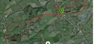
The route starts at the foot of Croy Hill, near the now closed Croy Miner’s Welfare. It is almost 100% trail with only 2 small road sections which account for c. 5% of the route. The trails themselves vary between hard packed paths, farm roads, muddy forest trail and grass sections, but in the main it is very runnable.
It starts with a sharp downhill before climbing to the top of Mount Cookie in Croy Hill. From there it descends back to the start and then up and over Bar Hill in to Twechar, this section is the reverse of parts of the ATR route and will be familiar to many. After a nice descent through Creecywood trail the race hits Twechar and a small road section for a few minutes. This precedes the toughest climb up to Bar Hill and towards the Roman ruins. The race will not go close to the ruins and runners will be guided away from these. A sharp descent off of Barr Hill and through the Howe Road trail to Auchinstarry follows before the final sharp uphill towards the finish from the Boathouse.
In all, there are 4 notable hills and around 1,000 feet of climb in the 10k. In the main, light trail or even road shoes if it is dry will be fine, but best to check nearer race day.
Detailed overview

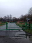
The race will start at the green gates in this picture. It has a sharp downhill right away for the the first kilometre. It follows a hard packed path, strewn with loose stones, down past the old Grotto. This local landmark was hand built by villagers and has recently been restored following some years of neglect.
Runners won’t see much of it as they thunder past on the downhill and vie for position on the trail.
The danger here is people get carried away and race down the hill as if it is a road 10k. The downhill lasts just shy of 1k. It will cause the field to thin out right away but it is also lulls the runners into a false sense of security as it is very quickly flipped from down to up in the next section.

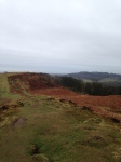
Right after the downhill the route turns to a hard-packed trail path that takes the runners up to the top what the people of Croy call Mount Cookie. It is a 250-300 foot climb in just over 1k. It has two mini-breaks it and goes from hard-packed path to grass for the final push on the climb. From the top runners can see from Arran in the west to Fife in the east. The Lomond Hills are just about visible on a good day. Off to the right are the Campsies above Kilsyth.
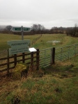
Coming off Mount Cookie the grass trail then runs down a really sharp descent, not without the odd rock to negotiate, back towards where the race starts. Here the route changes from 2015 and goes through the field and to the green gates on Howe Road. There is a road crossing here and runners will be expected to listen to the marshall’s instructions as it can get busy.
Runners who do the ATR ‘big’ race will be used to coming down this hill. The reverse climb is long but gradual, and very runnable. And it is then followed by a really nice descent through Creecywood Forest to Twechar.
This section is mainly on farm roads until the top, but if anywhere on the route is going to be wet and slightly muddy it will be on the downhill here. The path is beautiful but well shaded. When dry it is like a shaggy-piled carpet. Given this is Scotland, that’s an assumption as it is almost always a wee bit slippy and a wee bit muddy. It is absolute great fun to run down this trail though.
Once at the bottom the only tarmac section of note in the race is run. The route goes right at the end of the trail and through the village of Twechar towards the hill where the race will be won and lost and where most people will run their slowest miles.

This is 4 miles in. The path here is hard trail, with loose stones. It is hard, sharp and will test the runner’s leg strength. It is about 300 foot of climb in one kilometre.
Once at the top, runners will go around the Roman Ruins and down the Bar Hill descent back towards Croy. This is a grassy trail and can be slippy. It is a welcome relief though after the heart-rate increasing climb to the top of the hill.
Overall, the climb and descent from Twechar back towards Croy lasts two kilometres and is arguably the prettiest section of the route. And it signals the end of the really hard sections, with the 3 toughest climbs having been completed by this point.
At the bottom of the hill, instead of heading back into Croy – and tantalisingly the finish line will be

visible – the race veers off to the left and through the Howe Road trail towards Auchinstarry (well known for the Boathouse Restaurant). This little section has a wee short descent that will need nimble feet if it is wet out. At the end of the trail the route crosses the Glen Brae road and again, runners will need to listen to the advice of the marshals and cross safely. A change to the 2016 course sees the runners go all the way down the hill to the Boathouse and then from here it is all the way up hill to the finish, at the very green gates at which the course starts.